|
|
|||||||||||||||||
| Point ID: 3575 | Downloads | Plots | Site Data | Code: 07RD001 |
|
|
|||||||||||||||||
| Download | |
|---|---|
| Site Descriptor Information | Site Time Series Data |
| Link to all available data | |
| View: | Time Series | All |
| Units: | m3/s |
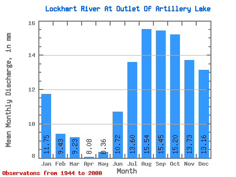
| Statistic | Jan | Feb | Mar | Apr | May | Jun | Jul | Aug | Sep | Oct | Nov | Dec | Annual |
|---|---|---|---|---|---|---|---|---|---|---|---|---|---|
| Mean | 11.74 | 9.51 | 9.23 | 8.08 | 8.36 | 10.72 | 13.60 | 15.54 | 15.45 | 15.20 | 13.73 | 13.16 | 144.61 |
| Standard Deviation | 2.71 | 2.12 | 1.96 | 1.64 | 1.66 | 2.54 | 3.51 | 4.10 | 4.01 | 4.14 | 3.64 | 3.28 | 30.30 |
| Min | 5.57 | 4.70 | 4.84 | 4.38 | 4.85 | 6.36 | 7.66 | 7.66 | 7.12 | 6.79 | 5.92 | 5.74 | 87.93 |
| Max | 18.52 | 14.40 | 13.49 | 11.69 | 11.78 | 20.27 | 25.77 | 27.69 | 25.92 | 24.26 | 22.12 | 21.14 | 219.40 |
| Coefficient of Variation | 0.23 | 0.22 | 0.21 | 0.20 | 0.20 | 0.24 | 0.26 | 0.26 | 0.26 | 0.27 | 0.27 | 0.25 | 0.21 |
 Return to R-Arctic Net Home Page