|
|
|||||||||||||||||
| Point ID: 3574 | Downloads | Plots | Site Data | Code: 07RC001 |
|
|
|||||||||||||||||
| Download | |
|---|---|
| Site Descriptor Information | Site Time Series Data |
| Link to all available data | |
| View: | Time Series | All |
| Units: | m3/s |
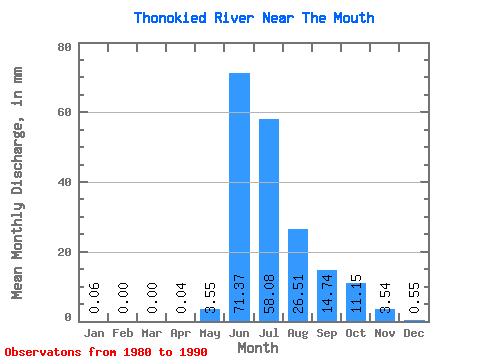
| Statistic | Jan | Feb | Mar | Apr | May | Jun | Jul | Aug | Sep | Oct | Nov | Dec | Annual |
|---|---|---|---|---|---|---|---|---|---|---|---|---|---|
| Mean | 0.06 | 0.00 | 0.00 | 0.04 | 3.54 | 71.37 | 58.07 | 26.51 | 14.74 | 11.14 | 3.54 | 0.55 | 165.34 |
| Standard Deviation | 0.13 | 0.00 | 0.00 | 0.10 | 5.04 | 36.66 | 26.70 | 8.99 | 5.07 | 5.48 | 2.90 | 0.66 | 45.02 |
| Min | 0.00 | 0.00 | 0.00 | 0.00 | 0.00 | 25.77 | 35.66 | 17.00 | 7.63 | 4.20 | 0.11 | 0.00 | 100.97 |
| Max | 0.33 | 0.00 | 0.00 | 0.25 | 12.46 | 134.70 | 121.41 | 45.59 | 24.32 | 22.42 | 8.26 | 1.56 | 217.41 |
| Coefficient of Variation | 2.12 | 2.45 | 1.42 | 0.51 | 0.46 | 0.34 | 0.34 | 0.49 | 0.82 | 1.20 | 0.27 |
 Return to R-Arctic Net Home Page