|
|
|||||||||||||||||
| Point ID: 3550 | Downloads | Plots | Site Data | Code: 06OA005 |
|
|
|||||||||||||||||
| Download | |
|---|---|
| Site Descriptor Information | Site Time Series Data |
| Link to all available data | |
| View: | Time Series | All |
| Units: | m3/s |
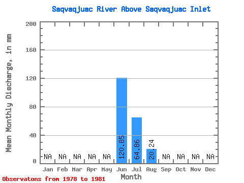
| Statistic | Jan | Feb | Mar | Apr | May | Jun | Jul | Aug | Sep | Oct | Nov | Dec | Annual |
|---|---|---|---|---|---|---|---|---|---|---|---|---|---|
| Mean | 120.85 | 64.85 | 20.24 | ||||||||||
| Standard Deviation | 13.10 | 14.46 | |||||||||||
| Min | 120.85 | 55.59 | 9.09 | ||||||||||
| Max | 120.85 | 74.12 | 36.57 | ||||||||||
| Coefficient of Variation | 0.20 | 0.71 |
 Return to R-Arctic Net Home Page