|
|
|||||||||||||||||
| Point ID: 3539 | Downloads | Plots | Site Data | Code: 06MA004 |
|
|
|||||||||||||||||
| Download | |
|---|---|
| Site Descriptor Information | Site Time Series Data |
| Link to all available data | |
| View: | Time Series | All |
| Units: | m3/s |
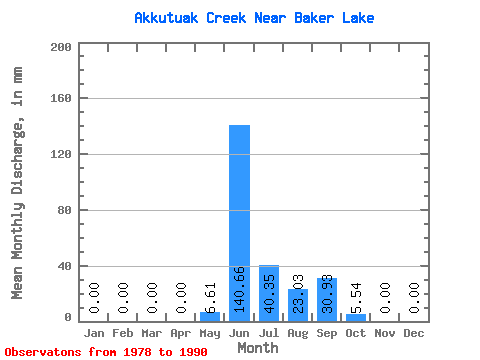
| Statistic | Jan | Feb | Mar | Apr | May | Jun | Jul | Aug | Sep | Oct | Nov | Dec | Annual |
|---|---|---|---|---|---|---|---|---|---|---|---|---|---|
| Mean | 0.00 | 0.00 | 0.00 | 0.00 | 6.54 | 140.62 | 40.35 | 23.11 | 30.88 | 5.55 | 0.00 | 0.00 | 267.91 |
| Standard Deviation | 0.00 | 0.00 | 0.00 | 0.00 | 14.56 | 37.58 | 33.08 | 18.33 | 21.97 | 5.29 | 0.00 | 0.00 | 68.19 |
| Min | 0.00 | 0.00 | 0.00 | 0.00 | 0.00 | 82.77 | 11.43 | 0.00 | 0.35 | 0.00 | 0.00 | 0.00 | 219.69 |
| Max | 0.00 | 0.00 | 0.00 | 0.00 | 37.31 | 210.82 | 131.40 | 52.49 | 65.49 | 12.68 | 0.00 | 0.00 | 316.13 |
| Coefficient of Variation | 2.23 | 0.27 | 0.82 | 0.79 | 0.71 | 0.95 | 0.26 |
 Return to R-Arctic Net Home Page