|
|
|||||||||||||||||
| Point ID: 3532 | Downloads | Plots | Site Data | Other Close Sites | Code: 06KC003 |
|
|
|||||||||||||||||
| Download | |
|---|---|
| Site Descriptor Information | Site Time Series Data |
| Link to all available data | |
| View: | Time Series | All |
| Units: | m3/s |
| Statistic | Jan | Feb | Mar | Apr | May | Jun | Jul | Aug | Sep | Oct | Nov | Dec | Annual |
|---|---|---|---|---|---|---|---|---|---|---|---|---|---|
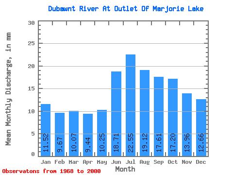
| Mean | 11.51 | 9.75 | 10.07 | 9.44 | 10.24 | 18.71 | 22.54 | 19.12 | 17.61 | 17.20 | 13.96 | 12.66 | 171.68 |
| Standard Deviation | 3.09 | 2.69 | 2.71 | 2.30 | 2.14 | 4.57 | 4.88 | 4.11 | 3.49 | 3.71 | 3.38 | 3.27 | 31.28 |
| Min | 6.25 | 5.29 | 5.65 | 5.78 | 6.21 | 10.17 | 14.09 | 11.90 | 11.82 | 9.83 | 7.32 | 6.92 | 116.69 |
| Max | 17.31 | 15.30 | 16.32 | 15.18 | 15.12 | 32.35 | 31.48 | 25.91 | 25.15 | 25.03 | 22.49 | 19.82 | 231.85 |
| Coefficient of Variation | 0.27 | 0.28 | 0.27 | 0.24 | 0.21 | 0.24 | 0.22 | 0.21 | 0.20 | 0.22 | 0.24 | 0.26 | 0.18 |
| Other Close Sites | ||||||
|---|---|---|---|---|---|---|
| PointID | Latitude | Longitude | Drainage Area | Source | Name | |
| 3531 | "DUBAWNT RIVER BELOW MARJORIE LAKE" | 64.34 | 480648 | Hydat | ||
 Return to R-Arctic Net Home Page