|
|
|||||||||||||||||
| Point ID: 353 | Downloads | Plots | Site Data | Code: 05BN014 |
|
|
|||||||||||||||||
| Download | |
|---|---|
| Site Descriptor Information | Site Time Series Data |
| Link to all available data | |
| View: | Time Series | All |
| Units: | m3/s |
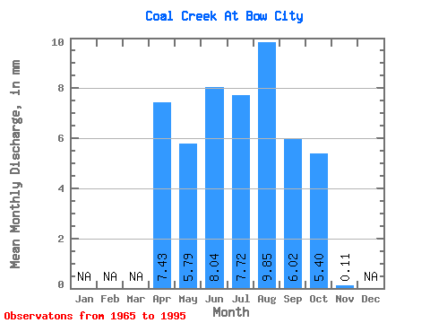
| Statistic | Jan | Feb | Mar | Apr | May | Jun | Jul | Aug | Sep | Oct | Nov | Dec | Annual |
|---|---|---|---|---|---|---|---|---|---|---|---|---|---|
| Mean | 5.82 | 4.54 | 6.30 | 6.06 | 7.72 | 4.73 | 4.23 | 0.09 | |||||
| Standard Deviation | 2.78 | 3.07 | 3.65 | 3.19 | 2.85 | 3.04 | |||||||
| Min | 5.82 | 0.18 | 0.98 | 1.45 | 2.87 | 0.60 | 0.49 | 0.09 | |||||
| Max | 5.82 | 12.40 | 10.57 | 16.54 | 14.56 | 12.66 | 12.12 | 0.09 | |||||
| Coefficient of Variation | 0.61 | 0.49 | 0.60 | 0.41 | 0.60 | 0.72 |
 Return to R-Arctic Net Home Page