|
|
|||||||||||||||||
| Point ID: 321 | Downloads | Plots | Site Data | Code: 05BL024 |
|
|
|||||||||||||||||
| Download | |
|---|---|
| Site Descriptor Information | Site Time Series Data |
| Link to all available data | |
| View: | Time Series | All |
| Units: | m3/s |
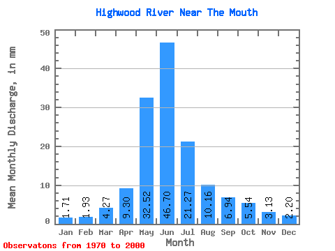
| Statistic | Jan | Feb | Mar | Apr | May | Jun | Jul | Aug | Sep | Oct | Nov | Dec | Annual |
|---|---|---|---|---|---|---|---|---|---|---|---|---|---|
| Mean | 1.70 | 1.94 | 4.25 | 9.28 | 32.44 | 46.58 | 21.21 | 10.13 | 6.92 | 5.53 | 3.13 | 2.20 | 144.81 |
| Standard Deviation | 0.60 | 1.31 | 3.09 | 4.50 | 16.30 | 23.90 | 15.65 | 6.84 | 4.84 | 3.10 | 1.56 | 0.92 | 56.21 |
| Min | 0.74 | 0.78 | 1.47 | 3.34 | 7.99 | 9.16 | 4.36 | 2.91 | 2.57 | 2.56 | 1.38 | 1.04 | 62.78 |
| Max | 3.36 | 6.85 | 12.55 | 19.94 | 74.50 | 103.29 | 69.13 | 33.63 | 25.20 | 16.31 | 8.57 | 4.61 | 277.78 |
| Coefficient of Variation | 0.35 | 0.68 | 0.73 | 0.48 | 0.50 | 0.51 | 0.74 | 0.68 | 0.70 | 0.56 | 0.50 | 0.42 | 0.39 |
 Return to R-Arctic Net Home Page