|
|
|||||||||||||||||
| Point ID: 3133 | Downloads | Plots | Site Data | Code: 06GA001 |
|
|
|||||||||||||||||
| Download | |
|---|---|
| Site Descriptor Information | Site Time Series Data |
| Link to all available data | |
| View: | Time Series | All |
| Units: | m3/s |
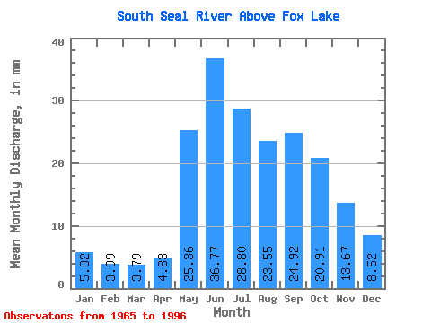
| Statistic | Jan | Feb | Mar | Apr | May | Jun | Jul | Aug | Sep | Oct | Nov | Dec | Annual |
|---|---|---|---|---|---|---|---|---|---|---|---|---|---|
| Mean | 5.82 | 4.02 | 3.79 | 4.83 | 25.36 | 36.77 | 28.80 | 23.55 | 24.92 | 20.91 | 13.67 | 8.52 | 186.91 |
| Standard Deviation | 2.05 | 1.19 | 1.10 | 3.49 | 12.33 | 14.90 | 13.37 | 14.00 | 18.16 | 13.08 | 7.63 | 4.10 | 49.81 |
| Min | 2.62 | 1.88 | 1.80 | 1.75 | 4.02 | 12.56 | 7.27 | 7.42 | 5.64 | 4.43 | 3.83 | 3.60 | 121.20 |
| Max | 11.08 | 6.34 | 6.08 | 16.27 | 44.50 | 71.78 | 60.56 | 57.47 | 71.18 | 53.15 | 35.89 | 21.42 | 298.32 |
| Coefficient of Variation | 0.35 | 0.29 | 0.29 | 0.72 | 0.49 | 0.41 | 0.46 | 0.59 | 0.73 | 0.63 | 0.56 | 0.48 | 0.27 |
 Return to R-Arctic Net Home Page