|
|
|||||||||||||||||
| Point ID: 3128 | Downloads | Plots | Site Data | Code: 06FB001 |
|
|
|||||||||||||||||
| Download | |
|---|---|
| Site Descriptor Information | Site Time Series Data |
| Link to all available data | |
| View: | Time Series | All |
| Units: | m3/s |
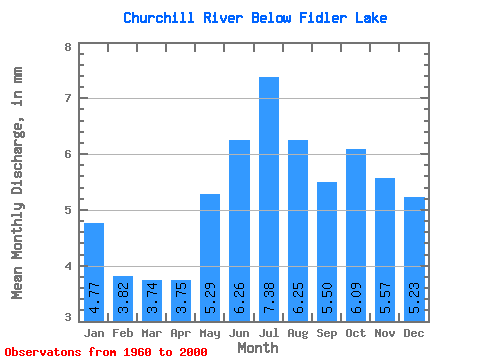
| Statistic | Jan | Feb | Mar | Apr | May | Jun | Jul | Aug | Sep | Oct | Nov | Dec | Annual |
|---|---|---|---|---|---|---|---|---|---|---|---|---|---|
| Mean | 4.64 | 3.75 | 3.65 | 3.65 | 5.15 | 6.10 | 7.19 | 6.08 | 5.35 | 5.93 | 5.43 | 5.10 | 59.27 |
| Standard Deviation | 4.37 | 3.66 | 3.86 | 3.90 | 4.53 | 5.20 | 6.36 | 5.54 | 5.12 | 5.40 | 4.82 | 4.74 | 52.45 |
| Min | 0.87 | 0.62 | 0.55 | 0.46 | 0.72 | 0.88 | 0.68 | 0.45 | 0.36 | 0.55 | 1.32 | 1.13 | 12.65 |
| Max | 12.75 | 10.71 | 11.17 | 10.52 | 13.54 | 16.74 | 21.15 | 16.40 | 14.82 | 15.12 | 14.73 | 13.64 | 155.28 |
| Coefficient of Variation | 0.94 | 0.97 | 1.06 | 1.07 | 0.88 | 0.85 | 0.89 | 0.91 | 0.96 | 0.91 | 0.89 | 0.93 | 0.89 |
 Return to R-Arctic Net Home Page