|
|
|||||||||||||||||
| Point ID: 3122 | Downloads | Plots | Site Data | Code: 06EB003 |
|
|
|||||||||||||||||
| Download | |
|---|---|
| Site Descriptor Information | Site Time Series Data |
| Link to all available data | |
| View: | Time Series | All |
| Units: | m3/s |
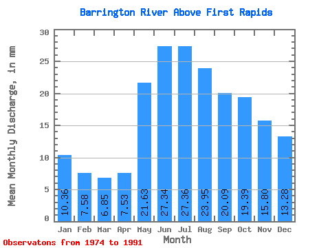
| Statistic | Jan | Feb | Mar | Apr | May | Jun | Jul | Aug | Sep | Oct | Nov | Dec | Annual |
|---|---|---|---|---|---|---|---|---|---|---|---|---|---|
| Mean | 10.36 | 7.64 | 6.85 | 7.53 | 21.62 | 27.34 | 27.35 | 23.94 | 20.09 | 19.39 | 15.80 | 13.28 | 190.86 |
| Standard Deviation | 4.91 | 3.17 | 2.58 | 4.09 | 7.79 | 10.30 | 11.05 | 11.11 | 11.00 | 13.64 | 10.42 | 7.19 | 57.40 |
| Min | 3.19 | 2.27 | 2.09 | 2.75 | 10.68 | 15.08 | 13.10 | 10.47 | 7.00 | 6.40 | 4.77 | 3.69 | 133.46 |
| Max | 20.58 | 14.61 | 12.27 | 16.99 | 37.52 | 50.52 | 49.02 | 47.96 | 47.89 | 48.72 | 37.93 | 28.29 | 289.08 |
| Coefficient of Variation | 0.47 | 0.41 | 0.38 | 0.54 | 0.36 | 0.38 | 0.40 | 0.46 | 0.55 | 0.70 | 0.66 | 0.54 | 0.30 |
 Return to R-Arctic Net Home Page