|
|
|||||||||||||||||
| Point ID: 3118 | Downloads | Plots | Site Data | Code: 05UH002 |
|
|
|||||||||||||||||
| Download | |
|---|---|
| Site Descriptor Information | Site Time Series Data |
| Link to all available data | |
| View: | Time Series | All |
| Units: | m3/s |
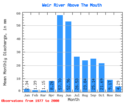
| Statistic | Jan | Feb | Mar | Apr | May | Jun | Jul | Aug | Sep | Oct | Nov | Dec | Annual |
|---|---|---|---|---|---|---|---|---|---|---|---|---|---|
| Mean | 2.34 | 1.40 | 1.15 | 8.26 | 57.69 | 52.96 | 26.52 | 23.84 | 25.14 | 21.68 | 9.17 | 4.29 | 233.82 |
| Standard Deviation | 1.06 | 0.53 | 0.37 | 12.45 | 29.61 | 35.18 | 17.70 | 20.31 | 20.21 | 17.83 | 5.49 | 2.15 | 74.84 |
| Min | 1.05 | 0.77 | 0.61 | 0.60 | 16.46 | 9.93 | 7.30 | 1.93 | 1.40 | 4.00 | 3.09 | 1.20 | 145.77 |
| Max | 4.37 | 2.74 | 2.03 | 43.16 | 108.72 | 174.78 | 75.80 | 66.46 | 72.29 | 90.17 | 25.33 | 8.93 | 389.60 |
| Coefficient of Variation | 0.45 | 0.38 | 0.32 | 1.51 | 0.51 | 0.66 | 0.67 | 0.85 | 0.80 | 0.82 | 0.60 | 0.50 | 0.32 |
 Return to R-Arctic Net Home Page