|
|
|||||||||||||||||
| Point ID: 3113 | Downloads | Plots | Site Data | Code: 05UF004 |
|
|
|||||||||||||||||
| Download | |
|---|---|
| Site Descriptor Information | Site Time Series Data |
| Link to all available data | |
| View: | Time Series | All |
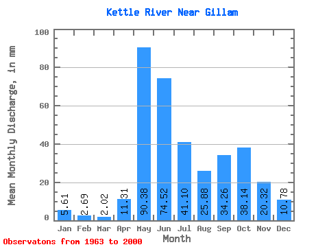
| Units: | m3/s |
| Statistic | Jan | Feb | Mar | Apr | May | Jun | Jul | Aug | Sep | Oct | Nov | Dec | Annual |
|---|---|---|---|---|---|---|---|---|---|---|---|---|---|
| Mean | 5.61 | 2.71 | 2.02 | 11.31 | 90.37 | 74.53 | 41.09 | 25.88 | 34.26 | 38.13 | 20.32 | 10.78 | 362.55 |
| Standard Deviation | 2.63 | 1.45 | 1.18 | 15.64 | 43.37 | 45.47 | 29.86 | 25.04 | 33.10 | 30.58 | 15.52 | 4.73 | 120.95 |
| Min | 0.75 | 0.39 | 0.46 | 0.71 | 10.96 | 15.17 | 7.47 | 2.06 | 1.76 | 4.40 | 4.23 | 3.83 | 178.97 |
| Max | 12.43 | 6.78 | 5.13 | 59.21 | 208.59 | 266.33 | 111.05 | 110.31 | 125.08 | 147.17 | 95.12 | 21.84 | 640.60 |
| Coefficient of Variation | 0.47 | 0.53 | 0.58 | 1.38 | 0.48 | 0.61 | 0.73 | 0.97 | 0.97 | 0.80 | 0.76 | 0.44 | 0.33 |
 Return to R-Arctic Net Home Page