|
|
|||||||||||||||||
| Point ID: 311 | Downloads | Plots | Site Data | Code: 05BL014 |
|
|
|||||||||||||||||
| Download | |
|---|---|
| Site Descriptor Information | Site Time Series Data |
| Link to all available data | |
| View: | Time Series | All |
| Units: | m3/s |
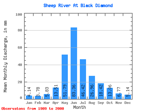
| Statistic | Jan | Feb | Mar | Apr | May | Jun | Jul | Aug | Sep | Oct | Nov | Dec | Annual |
|---|---|---|---|---|---|---|---|---|---|---|---|---|---|
| Mean | 4.14 | 3.81 | 5.83 | 13.51 | 51.78 | 83.36 | 46.41 | 26.96 | 18.42 | 13.06 | 6.77 | 5.14 | 260.41 |
| Standard Deviation | 0.82 | 1.05 | 2.68 | 6.60 | 27.25 | 51.76 | 34.05 | 18.93 | 11.95 | 6.16 | 2.15 | 1.42 | 90.34 |
| Min | 2.73 | 2.22 | 3.36 | 4.71 | 11.79 | 18.56 | 10.94 | 9.72 | 7.19 | 5.49 | 4.40 | 3.16 | 132.18 |
| Max | 5.99 | 7.42 | 13.64 | 38.47 | 121.97 | 276.19 | 129.62 | 113.42 | 56.63 | 33.76 | 14.90 | 8.46 | 476.80 |
| Coefficient of Variation | 0.20 | 0.27 | 0.46 | 0.49 | 0.53 | 0.62 | 0.73 | 0.70 | 0.65 | 0.47 | 0.32 | 0.28 | 0.35 |
 Return to R-Arctic Net Home Page