|
|
|||||||||||||||||
| Point ID: 3103 | Downloads | Plots | Site Data | Code: 05TG003 |
|
|
|||||||||||||||||
| Download | |
|---|---|
| Site Descriptor Information | Site Time Series Data |
| Link to all available data | |
| View: | Time Series | All |
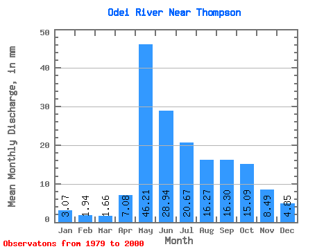
| Units: | m3/s |
| Statistic | Jan | Feb | Mar | Apr | May | Jun | Jul | Aug | Sep | Oct | Nov | Dec | Annual |
|---|---|---|---|---|---|---|---|---|---|---|---|---|---|
| Mean | 3.07 | 1.96 | 1.66 | 7.08 | 46.20 | 28.94 | 20.67 | 16.27 | 16.30 | 15.09 | 8.49 | 4.85 | 170.25 |
| Standard Deviation | 2.34 | 1.51 | 1.11 | 9.02 | 19.37 | 9.64 | 11.03 | 9.74 | 11.80 | 9.56 | 4.60 | 3.16 | 52.77 |
| Min | 0.39 | 0.22 | 0.20 | 0.49 | 15.68 | 14.67 | 5.55 | 5.72 | 4.65 | 3.91 | 3.42 | 0.80 | 87.19 |
| Max | 8.30 | 5.53 | 3.80 | 35.90 | 88.25 | 45.67 | 50.68 | 36.52 | 44.82 | 38.62 | 19.87 | 11.36 | 263.43 |
| Coefficient of Variation | 0.76 | 0.77 | 0.67 | 1.27 | 0.42 | 0.33 | 0.53 | 0.60 | 0.72 | 0.63 | 0.54 | 0.65 | 0.31 |
 Return to R-Arctic Net Home Page