|
|
|||||||||||||||||
| Point ID: 3097 | Downloads | Plots | Site Data | Code: 05TE001 |
|
|
|||||||||||||||||
| Download | |
|---|---|
| Site Descriptor Information | Site Time Series Data |
| Link to all available data | |
| View: | Time Series | All |
| Units: | m3/s |
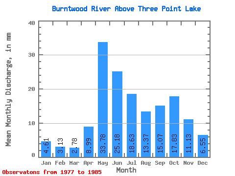
| Statistic | Jan | Feb | Mar | Apr | May | Jun | Jul | Aug | Sep | Oct | Nov | Dec | Annual |
|---|---|---|---|---|---|---|---|---|---|---|---|---|---|
| Mean | 4.61 | 3.16 | 2.78 | 8.99 | 33.77 | 25.18 | 18.63 | 13.36 | 15.07 | 17.83 | 11.13 | 6.54 | 158.69 |
| Standard Deviation | 0.89 | 0.41 | 0.49 | 7.70 | 12.60 | 11.58 | 7.41 | 2.20 | 8.14 | 7.76 | 3.03 | 1.93 | 28.99 |
| Min | 3.53 | 2.60 | 2.22 | 2.23 | 10.17 | 7.47 | 6.88 | 10.17 | 5.06 | 9.05 | 6.73 | 4.10 | 113.10 |
| Max | 6.11 | 3.92 | 3.83 | 23.51 | 53.08 | 40.48 | 31.73 | 16.61 | 28.84 | 27.70 | 16.39 | 10.25 | 193.22 |
| Coefficient of Variation | 0.19 | 0.13 | 0.17 | 0.86 | 0.37 | 0.46 | 0.40 | 0.17 | 0.54 | 0.43 | 0.27 | 0.29 | 0.18 |
 Return to R-Arctic Net Home Page