|
|
|||||||||||||||||
| Point ID: 3095 | Downloads | Plots | Site Data | Code: 05TB002 |
|
|
|||||||||||||||||
| Download | |
|---|---|
| Site Descriptor Information | Site Time Series Data |
| Link to all available data | |
| View: | Time Series | All |
| Units: | m3/s |
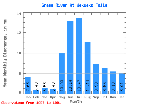
| Statistic | Jan | Feb | Mar | Apr | May | Jun | Jul | Aug | Sep | Oct | Nov | Dec | Annual |
|---|---|---|---|---|---|---|---|---|---|---|---|---|---|
| Mean | 7.63 | 6.46 | 6.58 | 6.48 | 10.00 | 13.14 | 13.47 | 11.12 | 8.93 | 8.55 | 8.19 | 8.01 | 109.15 |
| Standard Deviation | 3.52 | 2.64 | 2.43 | 2.23 | 3.91 | 6.35 | 7.26 | 6.58 | 5.03 | 4.65 | 4.46 | 4.17 | 44.66 |
| Min | 1.66 | 1.44 | 1.52 | 1.48 | 1.65 | 1.46 | 1.54 | 0.99 | 1.56 | 1.36 | 1.36 | 1.74 | 20.82 |
| Max | 15.24 | 11.79 | 11.29 | 11.72 | 19.61 | 26.88 | 37.33 | 35.19 | 24.80 | 19.36 | 16.91 | 17.55 | 211.56 |
| Coefficient of Variation | 0.46 | 0.41 | 0.37 | 0.34 | 0.39 | 0.48 | 0.54 | 0.59 | 0.56 | 0.54 | 0.54 | 0.52 | 0.41 |
 Return to R-Arctic Net Home Page