|
|
|||||||||||||||||
| Point ID: 3093 | Downloads | Plots | Site Data | Code: 05SD003 |
|
|
|||||||||||||||||
| Download | |
|---|---|
| Site Descriptor Information | Site Time Series Data |
| Link to all available data | |
| View: | Time Series | All |
| Units: | m3/s |
| Statistic | Jan | Feb | Mar | Apr | May | Jun | Jul | Aug | Sep | Oct | Nov | Dec | Annual |
|---|---|---|---|---|---|---|---|---|---|---|---|---|---|
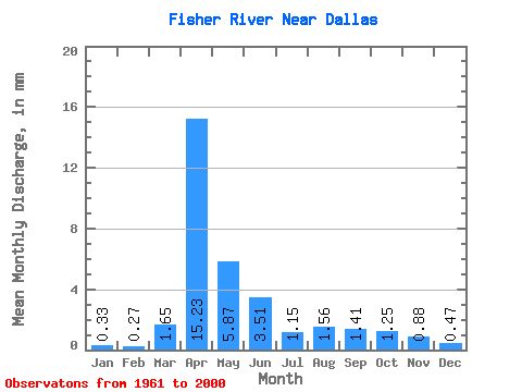
| Mean | 0.34 | 0.28 | 1.65 | 15.23 | 5.87 | 3.51 | 1.15 | 1.56 | 1.41 | 1.25 | 0.89 | 0.47 | 33.50 |
| Standard Deviation | 0.20 | 0.17 | 3.85 | 15.47 | 8.66 | 5.46 | 0.84 | 3.75 | 3.96 | 1.85 | 1.06 | 0.28 | 25.98 |
| Min | 0.09 | 0.03 | 0.09 | 0.78 | 0.37 | 0.38 | 0.35 | 0.16 | 0.21 | 0.23 | 0.27 | 0.14 | 5.23 |
| Max | 1.01 | 0.77 | 22.11 | 70.53 | 43.75 | 28.48 | 4.76 | 21.95 | 24.26 | 9.89 | 5.82 | 1.38 | 107.40 |
| Coefficient of Variation | 0.60 | 0.61 | 2.34 | 1.02 | 1.48 | 1.56 | 0.73 | 2.41 | 2.81 | 1.48 | 1.20 | 0.58 | 0.78 |
 Return to R-Arctic Net Home Page