|
|
|||||||||||||||||
| Point ID: 309 | Downloads | Plots | Site Data | Code: 05BL012 |
|
|
|||||||||||||||||
| Download | |
|---|---|
| Site Descriptor Information | Site Time Series Data |
| Link to all available data | |
| View: | Time Series | All |
| Units: | m3/s |
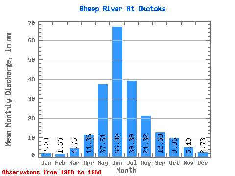
| Statistic | Jan | Feb | Mar | Apr | May | Jun | Jul | Aug | Sep | Oct | Nov | Dec | Annual |
|---|---|---|---|---|---|---|---|---|---|---|---|---|---|
| Mean | 2.03 | 1.62 | 4.75 | 11.36 | 37.50 | 66.80 | 39.38 | 21.32 | 12.63 | 9.86 | 5.18 | 2.73 | 171.53 |
| Standard Deviation | 0.53 | 0.89 | 3.56 | 6.43 | 22.63 | 48.25 | 48.83 | 18.30 | 11.15 | 5.28 | 4.67 | 1.48 | 74.25 |
| Min | 1.26 | 0.86 | 1.62 | 4.49 | 12.71 | 12.27 | 6.02 | 5.80 | 4.36 | 3.20 | 1.68 | 1.07 | 88.22 |
| Max | 2.79 | 3.48 | 10.02 | 22.46 | 83.91 | 167.79 | 198.17 | 72.84 | 41.47 | 19.28 | 16.36 | 5.52 | 246.42 |
| Coefficient of Variation | 0.26 | 0.55 | 0.75 | 0.57 | 0.60 | 0.72 | 1.24 | 0.86 | 0.88 | 0.54 | 0.90 | 0.54 | 0.43 |
 Return to R-Arctic Net Home Page