|
|
|||||||||||||||||
| Point ID: 308 | Downloads | Plots | Site Data | Code: 05BL009 |
|
|
|||||||||||||||||
| Download | |
|---|---|
| Site Descriptor Information | Site Time Series Data |
| Link to all available data | |
| View: | Time Series | All |
| Units: | m3/s |
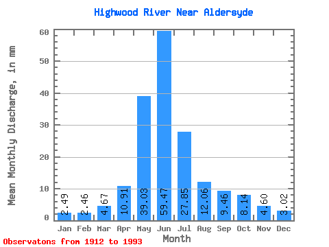
| Statistic | Jan | Feb | Mar | Apr | May | Jun | Jul | Aug | Sep | Oct | Nov | Dec | Annual |
|---|---|---|---|---|---|---|---|---|---|---|---|---|---|
| Mean | 2.49 | 2.48 | 4.67 | 10.91 | 39.02 | 59.47 | 27.84 | 12.05 | 9.46 | 8.14 | 4.60 | 3.02 | 188.17 |
| Standard Deviation | 1.40 | 1.33 | 3.45 | 7.00 | 18.68 | 32.10 | 18.43 | 8.45 | 9.66 | 7.25 | 2.66 | 1.17 | 58.73 |
| Min | 0.96 | 0.90 | 0.25 | 2.92 | 9.10 | 11.30 | 3.90 | 2.63 | 1.21 | 0.78 | 1.95 | 1.27 | 72.76 |
| Max | 9.07 | 7.85 | 20.14 | 42.76 | 102.89 | 163.94 | 84.12 | 41.43 | 54.94 | 43.83 | 13.18 | 6.35 | 376.34 |
| Coefficient of Variation | 0.56 | 0.54 | 0.74 | 0.64 | 0.48 | 0.54 | 0.66 | 0.70 | 1.02 | 0.89 | 0.58 | 0.39 | 0.31 |
 Return to R-Arctic Net Home Page