|
|
|||||||||||||||||
| Point ID: 307 | Downloads | Plots | Site Data | Code: 05BL008 |
|
|
|||||||||||||||||
| Download | |
|---|---|
| Site Descriptor Information | Site Time Series Data |
| Link to all available data | |
| View: | Time Series | All |
| Units: | m3/s |
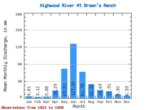
| Statistic | Jan | Feb | Mar | Apr | May | Jun | Jul | Aug | Sep | Oct | Nov | Dec | Annual |
|---|---|---|---|---|---|---|---|---|---|---|---|---|---|
| Mean | 4.81 | 3.15 | 3.88 | 18.29 | 69.50 | 127.93 | 61.74 | 32.82 | 18.69 | 15.91 | 9.30 | 6.33 | 298.06 |
| Standard Deviation | 0.87 | 0.84 | 0.96 | 8.80 | 30.67 | 62.33 | 43.76 | 14.89 | 8.37 | 4.84 | 4.78 | 2.19 | 113.18 |
| Min | 4.20 | 2.12 | 2.50 | 11.49 | 35.93 | 51.62 | 22.00 | 12.39 | 10.26 | 8.59 | 4.19 | 4.31 | 223.70 |
| Max | 6.07 | 3.92 | 4.71 | 32.62 | 112.25 | 224.64 | 137.25 | 59.81 | 36.07 | 23.66 | 15.70 | 9.17 | 428.32 |
| Coefficient of Variation | 0.18 | 0.27 | 0.25 | 0.48 | 0.44 | 0.49 | 0.71 | 0.45 | 0.45 | 0.30 | 0.51 | 0.35 | 0.38 |
 Return to R-Arctic Net Home Page