|
|
|||||||||||||||||
| Point ID: 306 | Downloads | Plots | Site Data | Code: 05BL007 |
|
|
|||||||||||||||||
| Download | |
|---|---|
| Site Descriptor Information | Site Time Series Data |
| Link to all available data | |
| View: | Time Series | All |
| Units: | m3/s |
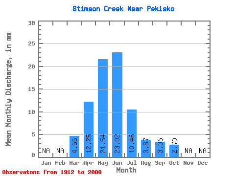
| Statistic | Jan | Feb | Mar | Apr | May | Jun | Jul | Aug | Sep | Oct | Nov | Dec | Annual |
|---|---|---|---|---|---|---|---|---|---|---|---|---|---|
| Mean | 4.66 | 12.25 | 21.54 | 23.02 | 10.45 | 3.87 | 3.36 | 2.70 | |||||
| Standard Deviation | 4.65 | 11.11 | 24.48 | 28.60 | 16.02 | 7.00 | 7.50 | 4.49 | |||||
| Min | 0.00 | 1.17 | 0.76 | 0.34 | 0.02 | 0.00 | 0.00 | 0.00 | |||||
| Max | 21.48 | 49.97 | 147.65 | 136.99 | 76.67 | 29.33 | 38.24 | 28.82 | |||||
| Coefficient of Variation | 1.00 | 0.91 | 1.14 | 1.24 | 1.53 | 1.81 | 2.23 | 1.66 |
 Return to R-Arctic Net Home Page