|
|
|||||||||||||||||
| Point ID: 3057 | Downloads | Plots | Site Data | Code: 05OJ013 |
|
|
|||||||||||||||||
| Download | |
|---|---|
| Site Descriptor Information | Site Time Series Data |
| Link to all available data | |
| View: | Time Series | All |
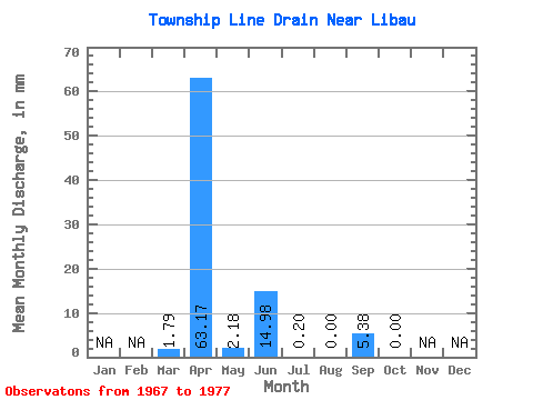
| Units: | m3/s |
| Statistic | Jan | Feb | Mar | Apr | May | Jun | Jul | Aug | Sep | Oct | Nov | Dec | Annual |
|---|---|---|---|---|---|---|---|---|---|---|---|---|---|
| Mean | 1.81 | 63.23 | 2.16 | 14.91 | 0.22 | 0.00 | 5.40 | 0.07 | |||||
| Standard Deviation | 5.42 | 40.93 | 2.27 | 24.43 | 0.25 | 0.00 | 16.19 | 0.20 | |||||
| Min | 0.00 | 1.34 | 0.00 | 0.00 | 0.00 | 0.00 | 0.00 | 0.00 | |||||
| Max | 16.27 | 135.36 | 6.75 | 72.19 | 0.59 | 0.00 | 48.58 | 0.59 | |||||
| Coefficient of Variation | 3.00 | 0.65 | 1.05 | 1.64 | 1.14 | 3.00 | 3.00 |
 Return to R-Arctic Net Home Page