|
|
|||||||||||||||||
| Point ID: 3043 | Downloads | Plots | Site Data | Code: 05OG010 |
|
|
|||||||||||||||||
| Download | |
|---|---|
| Site Descriptor Information | Site Time Series Data |
| Link to all available data | |
| View: | Time Series | All |
| Units: | m3/s |
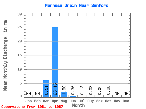
| Statistic | Jan | Feb | Mar | Apr | May | Jun | Jul | Aug | Sep | Oct | Nov | Dec | Annual |
|---|---|---|---|---|---|---|---|---|---|---|---|---|---|
| Mean | 6.10 | 25.14 | 1.79 | 0.38 | 0.12 | 0.10 | 0.00 | 0.08 | |||||
| Standard Deviation | 8.56 | 25.45 | 3.04 | 0.66 | 0.18 | 0.23 | 0.00 | 0.22 | |||||
| Min | 0.42 | 0.32 | 0.00 | 0.00 | 0.00 | 0.00 | 0.00 | 0.00 | |||||
| Max | 23.89 | 71.28 | 7.53 | 1.70 | 0.50 | 0.63 | 0.00 | 0.59 | |||||
| Coefficient of Variation | 1.41 | 1.01 | 1.70 | 1.76 | 1.50 | 2.46 | 2.65 |
 Return to R-Arctic Net Home Page