|
|
|||||||||||||||||
| Point ID: 3037 | Downloads | Plots | Site Data | Code: 05OG003 |
|
|
|||||||||||||||||
| Download | |
|---|---|
| Site Descriptor Information | Site Time Series Data |
| Link to all available data | |
| View: | Time Series | All |
| Units: | m3/s |
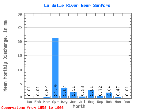
| Statistic | Jan | Feb | Mar | Apr | May | Jun | Jul | Aug | Sep | Oct | Nov | Dec | Annual |
|---|---|---|---|---|---|---|---|---|---|---|---|---|---|
| Mean | 0.00 | 0.01 | 0.52 | 21.08 | 3.67 | 2.31 | 0.58 | 2.81 | 0.72 | 2.04 | 0.47 | 0.01 | 31.32 |
| Standard Deviation | 0.01 | 0.01 | 0.98 | 14.61 | 3.77 | 3.95 | 1.22 | 7.69 | 1.29 | 5.74 | 1.31 | 0.03 | 17.93 |
| Min | 0.00 | 0.00 | 0.00 | 3.69 | 0.17 | 0.00 | 0.00 | 0.00 | 0.00 | 0.00 | 0.00 | 0.00 | 4.76 |
| Max | 0.04 | 0.04 | 2.62 | 43.73 | 12.23 | 11.08 | 3.55 | 21.83 | 3.24 | 16.25 | 3.71 | 0.08 | 52.34 |
| Coefficient of Variation | 2.83 | 2.83 | 1.90 | 0.69 | 1.03 | 1.71 | 2.13 | 2.74 | 1.80 | 2.82 | 2.81 | 2.83 | 0.57 |
 Return to R-Arctic Net Home Page