|
|
|||||||||||||||||
| Point ID: 3036 | Downloads | Plots | Site Data | Code: 05OG002 |
|
|
|||||||||||||||||
| Download | |
|---|---|
| Site Descriptor Information | Site Time Series Data |
| Link to all available data | |
| View: | Time Series | All |
| Units: | m3/s |
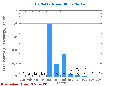
| Statistic | Jan | Feb | Mar | Apr | May | Jun | Jul | Aug | Sep | Oct | Nov | Dec | Annual |
|---|---|---|---|---|---|---|---|---|---|---|---|---|---|
| Mean | 1.61 | 0.38 | 0.69 | 0.09 | 0.05 | 0.01 | |||||||
| Standard Deviation | 1.35 | 0.18 | 0.87 | 0.12 | |||||||||
| Min | 0.65 | 0.25 | 0.08 | 0.01 | 0.05 | 0.01 | |||||||
| Max | 2.56 | 0.51 | 1.30 | 0.18 | 0.05 | 0.01 | |||||||
| Coefficient of Variation | 0.84 | 0.47 | 1.25 | 1.34 |
 Return to R-Arctic Net Home Page