|
|
|||||||||||||||||
| Point ID: 3029 | Downloads | Plots | Site Data | Code: 05OF017 |
|
|
|||||||||||||||||
| Download | |
|---|---|
| Site Descriptor Information | Site Time Series Data |
| Link to all available data | |
| View: | Time Series | All |
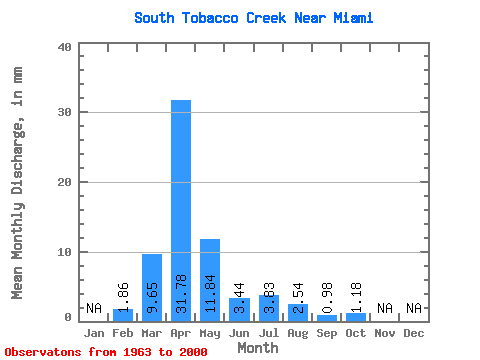
| Units: | m3/s |
| Statistic | Jan | Feb | Mar | Apr | May | Jun | Jul | Aug | Sep | Oct | Nov | Dec | Annual |
|---|---|---|---|---|---|---|---|---|---|---|---|---|---|
| Mean | 1.87 | 9.64 | 31.78 | 11.85 | 3.45 | 3.83 | 2.53 | 0.98 | 1.20 | ||||
| Standard Deviation | 13.97 | 30.09 | 15.68 | 3.92 | 6.51 | 9.21 | 2.67 | 3.36 | |||||
| Min | 1.87 | 0.00 | 0.20 | 0.07 | 0.00 | 0.00 | 0.00 | 0.00 | 0.00 | ||||
| Max | 1.87 | 53.98 | 115.28 | 58.16 | 16.92 | 25.07 | 50.49 | 12.30 | 16.47 | ||||
| Coefficient of Variation | 1.45 | 0.95 | 1.32 | 1.14 | 1.70 | 3.64 | 2.74 | 2.81 |
 Return to R-Arctic Net Home Page