|
|
|||||||||||||||||
| Point ID: 3022 | Downloads | Plots | Site Data | Code: 05OF009 |
|
|
|||||||||||||||||
| Download | |
|---|---|
| Site Descriptor Information | Site Time Series Data |
| Link to all available data | |
| View: | Time Series | All |
| Units: | m3/s |
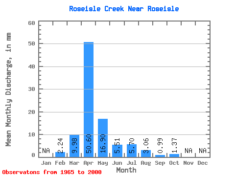
| Statistic | Jan | Feb | Mar | Apr | May | Jun | Jul | Aug | Sep | Oct | Nov | Dec | Annual |
|---|---|---|---|---|---|---|---|---|---|---|---|---|---|
| Mean | 2.26 | 9.97 | 50.61 | 16.90 | 5.51 | 5.70 | 3.06 | 0.99 | 1.36 | ||||
| Standard Deviation | 15.19 | 39.98 | 22.18 | 6.35 | 10.15 | 8.70 | 2.53 | 2.68 | |||||
| Min | 2.26 | 0.00 | 1.41 | 1.31 | 0.16 | 0.00 | 0.00 | 0.00 | 0.00 | ||||
| Max | 2.26 | 56.44 | 135.86 | 100.11 | 24.88 | 45.47 | 42.06 | 13.34 | 11.12 | ||||
| Coefficient of Variation | 1.52 | 0.79 | 1.31 | 1.15 | 1.78 | 2.84 | 2.56 | 1.97 |
 Return to R-Arctic Net Home Page