|
|
|||||||||||||||||
| Point ID: 3020 | Downloads | Plots | Site Data | Code: 05OF006 |
|
|
|||||||||||||||||
| Download | |
|---|---|
| Site Descriptor Information | Site Time Series Data |
| Link to all available data | |
| View: | Time Series | All |
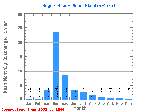
| Units: | m3/s |
| Statistic | Jan | Feb | Mar | Apr | May | Jun | Jul | Aug | Sep | Oct | Nov | Dec | Annual |
|---|---|---|---|---|---|---|---|---|---|---|---|---|---|
| Mean | 0.31 | 0.23 | 3.55 | 23.46 | 8.56 | 3.57 | 2.77 | 1.91 | 0.95 | 0.84 | 0.83 | 0.49 | 47.63 |
| Standard Deviation | 0.26 | 0.16 | 5.97 | 19.76 | 11.37 | 4.62 | 4.28 | 3.73 | 1.39 | 0.92 | 0.93 | 0.42 | 31.21 |
| Min | 0.00 | 0.00 | 0.00 | 0.05 | 0.85 | 0.19 | 0.05 | 0.03 | 0.02 | 0.03 | 0.01 | 0.00 | 6.24 |
| Max | 1.29 | 0.59 | 28.54 | 69.56 | 53.08 | 22.57 | 19.80 | 18.25 | 6.26 | 3.46 | 4.01 | 1.71 | 126.31 |
| Coefficient of Variation | 0.84 | 0.69 | 1.68 | 0.84 | 1.33 | 1.29 | 1.54 | 1.95 | 1.47 | 1.09 | 1.12 | 0.87 | 0.66 |
 Return to R-Arctic Net Home Page