|
|
|||||||||||||||||
| Point ID: 3013 | Downloads | Plots | Site Data | Code: 05OE010 |
|
|
|||||||||||||||||
| Download | |
|---|---|
| Site Descriptor Information | Site Time Series Data |
| Link to all available data | |
| View: | Time Series | All |
| Units: | m3/s |
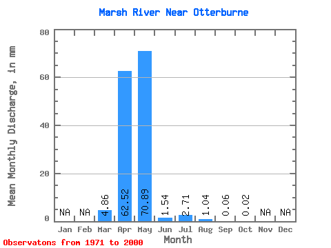
| Statistic | Jan | Feb | Mar | Apr | May | Jun | Jul | Aug | Sep | Oct | Nov | Dec | Annual |
|---|---|---|---|---|---|---|---|---|---|---|---|---|---|
| Mean | 4.86 | 62.52 | 70.88 | 1.54 | 2.71 | 1.04 | 0.06 | 0.02 | |||||
| Standard Deviation | 12.51 | 89.44 | 234.12 | 2.28 | 7.77 | 4.62 | 0.15 | 0.06 | |||||
| Min | 0.00 | 0.16 | 0.02 | 0.00 | 0.00 | 0.00 | 0.00 | 0.00 | |||||
| Max | 61.94 | 413.53 | 1226.57 | 6.23 | 34.62 | 22.21 | 0.61 | 0.30 | |||||
| Coefficient of Variation | 2.57 | 1.43 | 3.30 | 1.49 | 2.87 | 4.43 | 2.50 | 3.14 |
 Return to R-Arctic Net Home Page