|
|
|||||||||||||||||
| Point ID: 3012 | Downloads | Plots | Site Data | Code: 05OE009 |
|
|
|||||||||||||||||
| Download | |
|---|---|
| Site Descriptor Information | Site Time Series Data |
| Link to all available data | |
| View: | Time Series | All |
| Units: | m3/s |
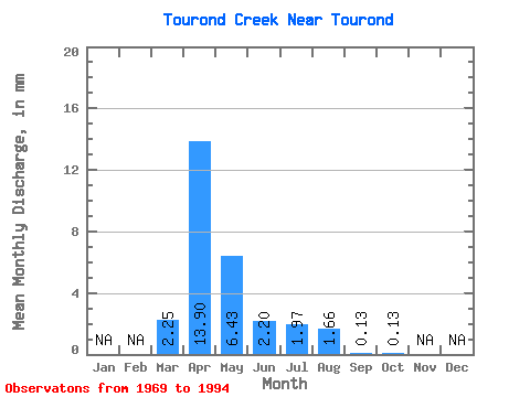
| Statistic | Jan | Feb | Mar | Apr | May | Jun | Jul | Aug | Sep | Oct | Nov | Dec | Annual |
|---|---|---|---|---|---|---|---|---|---|---|---|---|---|
| Mean | 2.25 | 13.89 | 6.43 | 2.20 | 1.96 | 1.66 | 0.13 | 0.13 | |||||
| Standard Deviation | 3.19 | 15.77 | 14.68 | 3.07 | 4.58 | 4.72 | 0.33 | 0.22 | |||||
| Min | 0.00 | 0.25 | 0.04 | 0.00 | 0.00 | 0.00 | 0.00 | 0.00 | |||||
| Max | 10.82 | 58.59 | 58.08 | 8.76 | 17.49 | 16.75 | 1.53 | 0.93 | |||||
| Coefficient of Variation | 1.42 | 1.14 | 2.28 | 1.40 | 2.33 | 2.85 | 2.45 | 1.69 |
 Return to R-Arctic Net Home Page