|
|
|||||||||||||||||
| Point ID: 3003 | Downloads | Plots | Site Data | Code: 05OD032 |
|
|
|||||||||||||||||
| Download | |
|---|---|
| Site Descriptor Information | Site Time Series Data |
| Link to all available data | |
| View: | Time Series | All |
| Units: | m3/s |
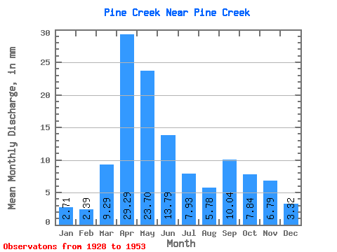
| Statistic | Jan | Feb | Mar | Apr | May | Jun | Jul | Aug | Sep | Oct | Nov | Dec | Annual |
|---|---|---|---|---|---|---|---|---|---|---|---|---|---|
| Mean | 2.71 | 2.42 | 9.28 | 29.29 | 23.69 | 13.79 | 7.92 | 5.78 | 10.04 | 7.84 | 6.79 | 3.32 | 152.75 |
| Standard Deviation | 0.85 | 0.59 | 11.60 | 14.23 | 16.38 | 11.70 | 6.88 | 5.46 | 14.23 | 5.88 | 4.12 | 0.85 | 50.28 |
| Min | 0.84 | 1.05 | 2.16 | 6.95 | 6.85 | 5.29 | 1.73 | 0.38 | 1.40 | 2.33 | 2.26 | 1.36 | 64.28 |
| Max | 3.89 | 3.10 | 42.82 | 63.29 | 84.15 | 43.81 | 23.25 | 22.84 | 58.55 | 23.25 | 20.00 | 4.38 | 267.43 |
| Coefficient of Variation | 0.32 | 0.24 | 1.25 | 0.49 | 0.69 | 0.85 | 0.87 | 0.94 | 1.42 | 0.75 | 0.61 | 0.26 | 0.33 |
 Return to R-Arctic Net Home Page