|
|
|||||||||||||||||
| Point ID: 300 | Downloads | Plots | Site Data | Code: 05BK001 |
|
|
|||||||||||||||||
| Download | |
|---|---|
| Site Descriptor Information | Site Time Series Data |
| Link to all available data | |
| View: | Time Series | All |
| Units: | m3/s |
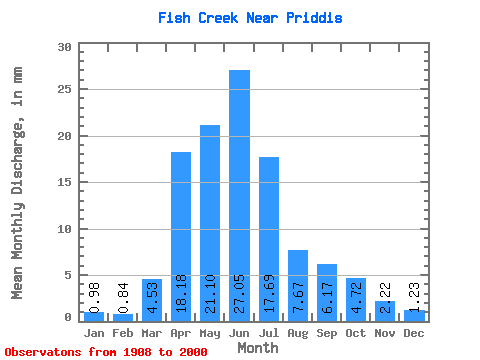
| Statistic | Jan | Feb | Mar | Apr | May | Jun | Jul | Aug | Sep | Oct | Nov | Dec | Annual |
|---|---|---|---|---|---|---|---|---|---|---|---|---|---|
| Mean | 0.98 | 0.85 | 4.53 | 18.18 | 21.09 | 27.05 | 17.69 | 7.67 | 6.17 | 4.71 | 2.22 | 1.23 | 103.89 |
| Standard Deviation | 0.76 | 0.61 | 4.73 | 12.74 | 16.19 | 38.50 | 33.02 | 13.52 | 12.34 | 6.18 | 1.90 | 0.76 | 46.58 |
| Min | 0.00 | 0.03 | 0.00 | 2.53 | 2.29 | 1.18 | 0.10 | 0.04 | 0.00 | 0.23 | 0.77 | 0.30 | 51.31 |
| Max | 3.03 | 1.94 | 19.02 | 49.24 | 71.14 | 238.18 | 207.83 | 65.24 | 80.26 | 35.57 | 5.97 | 2.42 | 192.03 |
| Coefficient of Variation | 0.78 | 0.72 | 1.04 | 0.70 | 0.77 | 1.42 | 1.87 | 1.76 | 2.00 | 1.31 | 0.86 | 0.62 | 0.45 |
 Return to R-Arctic Net Home Page