|
|
|||||||||||||||||
| Point ID: 30 | Downloads | Plots | Site Data | Code: 05AB007 |
|
|
|||||||||||||||||
| Download | |
|---|---|
| Site Descriptor Information | Site Time Series Data |
| Link to all available data | |
| View: | Time Series | All |
| Units: | m3/s |
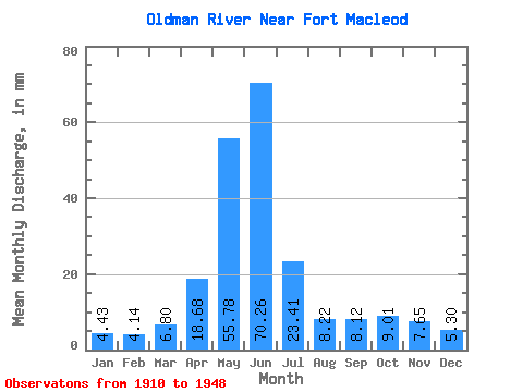
| Statistic | Jan | Feb | Mar | Apr | May | Jun | Jul | Aug | Sep | Oct | Nov | Dec | Annual |
|---|---|---|---|---|---|---|---|---|---|---|---|---|---|
| Mean | 4.36 | 4.11 | 6.70 | 18.42 | 54.99 | 69.28 | 23.08 | 8.10 | 8.00 | 8.88 | 7.55 | 5.23 | 209.77 |
| Standard Deviation | 1.86 | 2.77 | 3.99 | 11.10 | 24.25 | 41.46 | 16.58 | 7.35 | 10.22 | 7.34 | 4.13 | 2.30 | 85.95 |
| Min | 2.00 | 1.69 | 2.65 | 1.53 | 7.11 | 13.41 | 1.17 | 0.36 | 0.36 | 0.95 | 3.02 | 2.37 | 44.34 |
| Max | 11.25 | 15.76 | 17.81 | 51.75 | 113.44 | 200.70 | 66.48 | 27.38 | 51.75 | 27.57 | 17.50 | 12.13 | 410.40 |
| Coefficient of Variation | 0.43 | 0.67 | 0.59 | 0.60 | 0.44 | 0.60 | 0.72 | 0.91 | 1.28 | 0.83 | 0.55 | 0.44 | 0.41 |
 Return to R-Arctic Net Home Page