|
|
|||||||||||||||||
| Point ID: 2997 | Downloads | Plots | Site Data | Code: 05OD014 |
|
|
|||||||||||||||||
| Download | |
|---|---|
| Site Descriptor Information | Site Time Series Data |
| Link to all available data | |
| View: | Time Series | All |
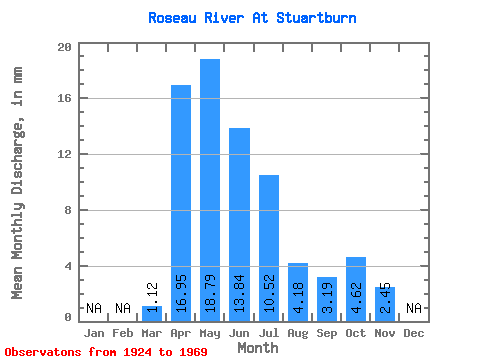
| Units: | m3/s |
| Statistic | Jan | Feb | Mar | Apr | May | Jun | Jul | Aug | Sep | Oct | Nov | Dec | Annual |
|---|---|---|---|---|---|---|---|---|---|---|---|---|---|
| Mean | 1.12 | 16.95 | 18.79 | 13.84 | 10.52 | 4.18 | 3.19 | 4.62 | 2.45 | ||||
| Standard Deviation | 2.12 | 12.16 | 17.26 | 10.89 | 10.13 | 7.29 | 6.27 | 5.20 | |||||
| Min | 0.00 | 3.41 | 1.11 | 0.79 | 0.17 | 0.00 | 0.02 | 0.03 | 2.45 | ||||
| Max | 6.25 | 43.49 | 52.31 | 34.85 | 30.23 | 28.98 | 27.30 | 13.75 | 2.45 | ||||
| Coefficient of Variation | 1.89 | 0.72 | 0.92 | 0.79 | 0.96 | 1.74 | 1.97 | 1.13 |
 Return to R-Arctic Net Home Page