|
|
|||||||||||||||||
| Point ID: 2996 | Downloads | Plots | Site Data | Code: 05OD004 |
|
|
|||||||||||||||||
| Download | |
|---|---|
| Site Descriptor Information | Site Time Series Data |
| Link to all available data | |
| View: | Time Series | All |
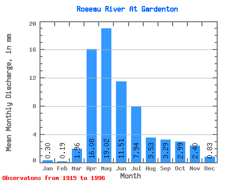
| Units: | m3/s |
| Statistic | Jan | Feb | Mar | Apr | May | Jun | Jul | Aug | Sep | Oct | Nov | Dec | Annual |
|---|---|---|---|---|---|---|---|---|---|---|---|---|---|
| Mean | 0.30 | 0.19 | 1.96 | 16.08 | 19.01 | 11.51 | 7.94 | 3.54 | 3.29 | 2.98 | 2.40 | 0.83 | 87.72 |
| Standard Deviation | 0.41 | 0.22 | 3.78 | 10.15 | 17.10 | 11.24 | 8.16 | 6.43 | 6.18 | 3.93 | 2.43 | 0.97 | 41.72 |
| Min | 0.02 | 0.00 | 0.00 | 0.75 | 0.62 | 0.14 | 0.02 | 0.02 | 0.01 | 0.01 | 0.16 | 0.07 | 24.27 |
| Max | 1.90 | 0.99 | 16.47 | 41.69 | 53.99 | 46.41 | 29.77 | 28.24 | 26.51 | 12.93 | 9.27 | 4.70 | 148.01 |
| Coefficient of Variation | 1.35 | 1.16 | 1.93 | 0.63 | 0.90 | 0.98 | 1.03 | 1.82 | 1.88 | 1.32 | 1.01 | 1.18 | 0.48 |
 Return to R-Arctic Net Home Page