|
|
|||||||||||||||||
| Point ID: 2992 | Downloads | Plots | Site Data | Code: 05OC025 |
|
|
|||||||||||||||||
| Download | |
|---|---|
| Site Descriptor Information | Site Time Series Data |
| Link to all available data | |
| View: | Time Series | All |
| Units: | m3/s |
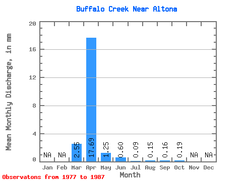
| Statistic | Jan | Feb | Mar | Apr | May | Jun | Jul | Aug | Sep | Oct | Nov | Dec | Annual |
|---|---|---|---|---|---|---|---|---|---|---|---|---|---|
| Mean | 2.55 | 17.69 | 1.25 | 0.60 | 0.09 | 0.16 | 0.16 | 0.19 | |||||
| Standard Deviation | 3.61 | 29.09 | 2.41 | 0.98 | 0.19 | 0.43 | 0.39 | 0.31 | |||||
| Min | 0.00 | 0.25 | 0.00 | 0.00 | 0.00 | 0.00 | 0.00 | 0.00 | |||||
| Max | 9.52 | 98.42 | 8.22 | 2.89 | 0.63 | 1.46 | 1.33 | 0.82 | |||||
| Coefficient of Variation | 1.41 | 1.64 | 1.93 | 1.64 | 2.08 | 2.79 | 2.43 | 1.64 |
 Return to R-Arctic Net Home Page