|
|
|||||||||||||||||
| Point ID: 2983 | Downloads | Plots | Site Data | Code: 05OC012 |
|
|
|||||||||||||||||
| Download | |
|---|---|
| Site Descriptor Information | Site Time Series Data |
| Link to all available data | |
| View: | Time Series | All |
| Units: | m3/s |
| Statistic | Jan | Feb | Mar | Apr | May | Jun | Jul | Aug | Sep | Oct | Nov | Dec | Annual |
|---|---|---|---|---|---|---|---|---|---|---|---|---|---|
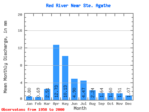
| Mean | 0.80 | 0.70 | 2.51 | 12.73 | 10.12 | 4.90 | 4.47 | 2.24 | 1.64 | 1.60 | 1.51 | 1.07 | 45.76 |
| Standard Deviation | 0.45 | 0.38 | 3.00 | 7.92 | 11.54 | 3.67 | 4.16 | 3.15 | 1.63 | 1.16 | 1.72 | 0.76 | 25.55 |
| Min | 0.08 | 0.11 | 0.19 | 1.22 | 0.92 | 0.61 | 0.34 | 0.19 | 0.19 | 0.20 | 0.17 | 0.11 | 6.86 |
| Max | 1.77 | 1.61 | 15.09 | 34.48 | 52.16 | 16.75 | 19.49 | 20.28 | 7.75 | 5.29 | 10.73 | 3.45 | 112.47 |
| Coefficient of Variation | 0.56 | 0.54 | 1.20 | 0.62 | 1.14 | 0.75 | 0.93 | 1.41 | 0.99 | 0.72 | 1.14 | 0.70 | 0.56 |
 Return to R-Arctic Net Home Page