|
|
|||||||||||||||||
| Point ID: 2981 | Downloads | Plots | Site Data | Code: 05OC004 |
|
|
|||||||||||||||||
| Download | |
|---|---|
| Site Descriptor Information | Site Time Series Data |
| Link to all available data | |
| View: | Time Series | All |
| Units: | m3/s |
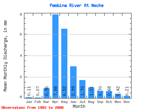
| Statistic | Jan | Feb | Mar | Apr | May | Jun | Jul | Aug | Sep | Oct | Nov | Dec | Annual |
|---|---|---|---|---|---|---|---|---|---|---|---|---|---|
| Mean | 0.11 | 0.07 | 0.96 | 7.88 | 6.52 | 2.99 | 1.70 | 1.01 | 0.69 | 0.68 | 0.42 | 0.21 | 23.79 |
| Standard Deviation | 0.16 | 0.10 | 1.75 | 8.77 | 8.56 | 3.35 | 2.10 | 1.53 | 0.91 | 0.82 | 0.55 | 0.31 | 23.36 |
| Min | 0.00 | 0.00 | 0.00 | 0.21 | 0.10 | 0.06 | 0.00 | 0.00 | 0.00 | 0.00 | 0.00 | 0.00 | 0.42 |
| Max | 1.07 | 0.54 | 10.86 | 40.65 | 42.63 | 16.38 | 13.48 | 8.46 | 5.62 | 5.75 | 4.22 | 2.33 | 110.88 |
| Coefficient of Variation | 1.40 | 1.32 | 1.82 | 1.11 | 1.31 | 1.12 | 1.24 | 1.51 | 1.30 | 1.21 | 1.30 | 1.47 | 0.98 |
 Return to R-Arctic Net Home Page