|
|
|||||||||||||||||
| Point ID: 2978 | Downloads | Plots | Site Data | Code: 05OB031 |
|
|
|||||||||||||||||
| Download | |
|---|---|
| Site Descriptor Information | Site Time Series Data |
| Link to all available data | |
| View: | Time Series | All |
| Units: | m3/s |
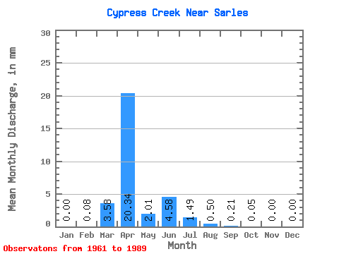
| Statistic | Jan | Feb | Mar | Apr | May | Jun | Jul | Aug | Sep | Oct | Nov | Dec | Annual |
|---|---|---|---|---|---|---|---|---|---|---|---|---|---|
| Mean | 0.00 | 0.08 | 3.57 | 20.33 | 2.02 | 4.58 | 1.49 | 0.51 | 0.21 | 0.05 | 0.00 | 0.01 | 33.33 |
| Standard Deviation | 0.00 | 0.41 | 6.81 | 23.70 | 4.30 | 12.17 | 3.88 | 1.72 | 1.09 | 0.22 | 0.02 | 0.03 | 28.57 |
| Min | 0.00 | 0.00 | 0.00 | 0.02 | 0.00 | 0.00 | 0.00 | 0.00 | 0.00 | 0.00 | 0.00 | 0.00 | 1.29 |
| Max | 0.00 | 2.18 | 24.98 | 84.02 | 21.75 | 57.76 | 15.47 | 8.39 | 5.86 | 1.15 | 0.09 | 0.18 | 107.05 |
| Coefficient of Variation | 5.29 | 1.91 | 1.17 | 2.13 | 2.66 | 2.60 | 3.36 | 5.05 | 4.15 | 4.54 | 5.38 | 0.86 |
 Return to R-Arctic Net Home Page