|
|
|||||||||||||||||
| Point ID: 2976 | Downloads | Plots | Site Data | Code: 05OB023 |
|
|
|||||||||||||||||
| Download | |
|---|---|
| Site Descriptor Information | Site Time Series Data |
| Link to all available data | |
| View: | Time Series | All |
| Units: | m3/s |
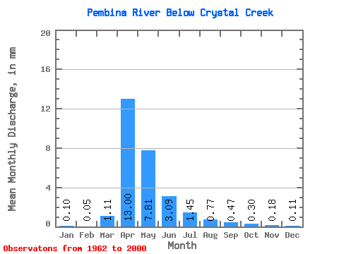
| Statistic | Jan | Feb | Mar | Apr | May | Jun | Jul | Aug | Sep | Oct | Nov | Dec | Annual |
|---|---|---|---|---|---|---|---|---|---|---|---|---|---|
| Mean | 0.10 | 0.05 | 1.11 | 13.01 | 7.81 | 3.09 | 1.45 | 0.77 | 0.47 | 0.30 | 0.17 | 0.11 | 26.33 |
| Standard Deviation | 0.21 | 0.08 | 1.75 | 15.26 | 9.29 | 3.81 | 1.67 | 1.39 | 1.23 | 0.70 | 0.53 | 0.25 | 25.54 |
| Min | 0.00 | 0.00 | 0.00 | 0.04 | 0.05 | 0.02 | 0.01 | 0.00 | 0.00 | 0.00 | 0.00 | 0.00 | 0.22 |
| Max | 0.94 | 0.30 | 5.94 | 53.17 | 35.23 | 16.93 | 6.29 | 8.03 | 7.42 | 3.15 | 3.10 | 1.30 | 95.78 |
| Coefficient of Variation | 2.00 | 1.60 | 1.57 | 1.17 | 1.19 | 1.23 | 1.16 | 1.79 | 2.59 | 2.37 | 3.05 | 2.24 | 0.97 |
 Return to R-Arctic Net Home Page