|
|
|||||||||||||||||
| Point ID: 2975 | Downloads | Plots | Site Data | Code: 05OB021 |
|
|
|||||||||||||||||
| Download | |
|---|---|
| Site Descriptor Information | Site Time Series Data |
| Link to all available data | |
| View: | Time Series | All |
| Units: | m3/s |
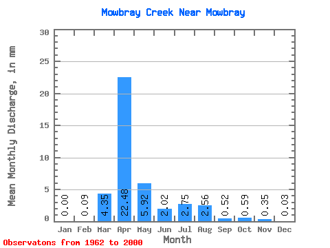
| Statistic | Jan | Feb | Mar | Apr | May | Jun | Jul | Aug | Sep | Oct | Nov | Dec | Annual |
|---|---|---|---|---|---|---|---|---|---|---|---|---|---|
| Mean | 0.00 | 0.10 | 4.36 | 22.47 | 5.92 | 2.01 | 2.75 | 2.56 | 0.52 | 0.59 | 0.34 | 0.03 | 61.48 |
| Standard Deviation | 0.01 | 0.37 | 8.08 | 24.25 | 10.92 | 3.31 | 9.07 | 9.72 | 1.51 | 2.62 | 1.18 | 0.10 | 59.05 |
| Min | 0.00 | 0.00 | 0.00 | 0.12 | 0.00 | 0.00 | 0.00 | 0.00 | 0.00 | 0.00 | 0.00 | 0.00 | 2.83 |
| Max | 0.02 | 1.50 | 35.47 | 96.46 | 46.10 | 16.23 | 54.79 | 46.61 | 7.99 | 16.35 | 4.60 | 0.39 | 196.76 |
| Coefficient of Variation | 3.87 | 3.85 | 1.86 | 1.08 | 1.84 | 1.65 | 3.30 | 3.80 | 2.91 | 4.42 | 3.43 | 3.67 | 0.96 |
 Return to R-Arctic Net Home Page