|
|
|||||||||||||||||
| Point ID: 2971 | Downloads | Plots | Site Data | Code: 05OB010 |
|
|
|||||||||||||||||
| Download | |
|---|---|
| Site Descriptor Information | Site Time Series Data |
| Link to all available data | |
| View: | Time Series | All |
| Units: | m3/s |
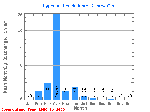
| Statistic | Jan | Feb | Mar | Apr | May | Jun | Jul | Aug | Sep | Oct | Nov | Dec | Annual |
|---|---|---|---|---|---|---|---|---|---|---|---|---|---|
| Mean | 2.18 | 3.80 | 19.95 | 2.15 | 2.94 | 0.82 | 0.53 | 0.13 | 0.29 | ||||
| Standard Deviation | 7.40 | 22.90 | 3.82 | 8.99 | 1.78 | 1.38 | 0.55 | 1.68 | |||||
| Min | 2.18 | 0.00 | 0.03 | 0.00 | 0.00 | 0.00 | 0.00 | 0.00 | 0.00 | ||||
| Max | 2.18 | 31.15 | 89.87 | 16.15 | 49.37 | 7.67 | 6.08 | 3.34 | 10.36 | ||||
| Coefficient of Variation | 1.95 | 1.15 | 1.78 | 3.06 | 2.17 | 2.58 | 4.34 | 5.84 |
 Return to R-Arctic Net Home Page