|
|
|||||||||||||||||
| Point ID: 2967 | Downloads | Plots | Site Data | Code: 05OB003 |
|
|
|||||||||||||||||
| Download | |
|---|---|
| Site Descriptor Information | Site Time Series Data |
| Link to all available data | |
| View: | Time Series | All |
| Units: | m3/s |
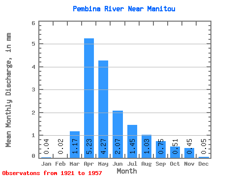
| Statistic | Jan | Feb | Mar | Apr | May | Jun | Jul | Aug | Sep | Oct | Nov | Dec | Annual |
|---|---|---|---|---|---|---|---|---|---|---|---|---|---|
| Mean | 0.04 | 0.02 | 1.17 | 5.23 | 4.27 | 2.07 | 1.45 | 1.03 | 0.75 | 0.51 | 0.45 | 0.06 | |
| Standard Deviation | 1.64 | 5.34 | 5.03 | 2.34 | 2.33 | 1.67 | 1.07 | 0.68 | 0.62 | ||||
| Min | 0.04 | 0.02 | 0.00 | 0.14 | 0.05 | 0.01 | 0.00 | 0.00 | 0.00 | 0.00 | 0.00 | 0.06 | |
| Max | 0.04 | 0.02 | 5.40 | 27.22 | 21.57 | 11.48 | 10.66 | 8.32 | 4.08 | 2.85 | 1.64 | 0.06 | |
| Coefficient of Variation | 1.40 | 1.02 | 1.18 | 1.13 | 1.60 | 1.62 | 1.43 | 1.33 | 1.38 |
 Return to R-Arctic Net Home Page