|
|
|||||||||||||||||
| Point ID: 2946 | Downloads | Plots | Site Data | Code: 05NG017 |
|
|
|||||||||||||||||
| Download | |
|---|---|
| Site Descriptor Information | Site Time Series Data |
| Link to all available data | |
| View: | Time Series | All |
| Units: | m3/s |
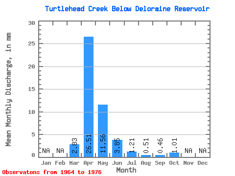
| Statistic | Jan | Feb | Mar | Apr | May | Jun | Jul | Aug | Sep | Oct | Nov | Dec | Annual |
|---|---|---|---|---|---|---|---|---|---|---|---|---|---|
| Mean | 2.83 | 26.51 | 11.54 | 3.84 | 1.21 | 0.51 | 0.47 | 1.03 | |||||
| Standard Deviation | 6.13 | 23.73 | 9.47 | 4.74 | 1.88 | 1.52 | 1.08 | 2.55 | |||||
| Min | 0.00 | 0.33 | 0.17 | 0.03 | 0.00 | 0.00 | 0.00 | 0.00 | |||||
| Max | 20.41 | 77.92 | 29.41 | 16.37 | 5.89 | 5.52 | 3.42 | 9.10 | |||||
| Coefficient of Variation | 2.17 | 0.90 | 0.82 | 1.23 | 1.55 | 2.98 | 2.30 | 2.48 |
 Return to R-Arctic Net Home Page