|
|
|||||||||||||||||
| Point ID: 2936 | Downloads | Plots | Site Data | Code: 05NF015 |
|
|
|||||||||||||||||
| Download | |
|---|---|
| Site Descriptor Information | Site Time Series Data |
| Link to all available data | |
| View: | Time Series | All |
| Units: | m3/s |
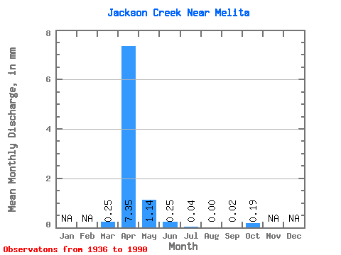
| Statistic | Jan | Feb | Mar | Apr | May | Jun | Jul | Aug | Sep | Oct | Nov | Dec | Annual |
|---|---|---|---|---|---|---|---|---|---|---|---|---|---|
| Mean | 0.25 | 7.36 | 1.14 | 0.26 | 0.04 | 0.00 | 0.02 | 0.19 | |||||
| Standard Deviation | 0.58 | 22.16 | 2.65 | 0.94 | 0.12 | 0.00 | 0.07 | 0.75 | |||||
| Min | 0.00 | 0.00 | 0.00 | 0.00 | 0.00 | 0.00 | 0.00 | 0.00 | |||||
| Max | 1.86 | 89.40 | 10.16 | 3.77 | 0.47 | 0.01 | 0.28 | 3.01 | |||||
| Coefficient of Variation | 2.35 | 3.01 | 2.34 | 3.68 | 2.98 | 4.00 | 4.00 | 4.00 |
 Return to R-Arctic Net Home Page