|
|
|||||||||||||||||
| Point ID: 2926 | Downloads | Plots | Site Data | Code: 05MJ011 |
|
|
|||||||||||||||||
| Download | |
|---|---|
| Site Descriptor Information | Site Time Series Data |
| Link to all available data | |
| View: | Time Series | All |
| Units: | m3/s |
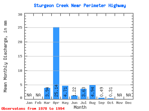
| Statistic | Jan | Feb | Mar | Apr | May | Jun | Jul | Aug | Sep | Oct | Nov | Dec | Annual |
|---|---|---|---|---|---|---|---|---|---|---|---|---|---|
| Mean | 3.94 | 25.14 | 4.71 | 1.22 | 3.62 | 4.94 | 0.48 | 0.30 | |||||
| Standard Deviation | 5.48 | 23.70 | 10.28 | 2.00 | 8.95 | 16.20 | 1.02 | 0.42 | |||||
| Min | 0.00 | 1.06 | 0.10 | 0.00 | 0.03 | 0.00 | 0.00 | 0.00 | |||||
| Max | 18.76 | 80.58 | 32.60 | 7.09 | 27.78 | 63.19 | 3.76 | 1.59 | |||||
| Coefficient of Variation | 1.39 | 0.94 | 2.18 | 1.64 | 2.47 | 3.28 | 2.11 | 1.38 |
 Return to R-Arctic Net Home Page