|
|
|||||||||||||||||
| Point ID: 2924 | Downloads | Plots | Site Data | Code: 05MJ009 |
|
|
|||||||||||||||||
| Download | |
|---|---|
| Site Descriptor Information | Site Time Series Data |
| Link to all available data | |
| View: | Time Series | All |
| Units: | m3/s |
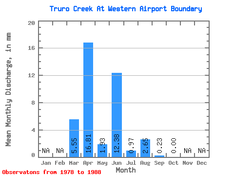
| Statistic | Jan | Feb | Mar | Apr | May | Jun | Jul | Aug | Sep | Oct | Nov | Dec | Annual |
|---|---|---|---|---|---|---|---|---|---|---|---|---|---|
| Mean | 5.59 | 16.70 | 1.81 | 12.38 | 0.84 | 2.69 | 0.31 | 0.00 | |||||
| Standard Deviation | 12.88 | 20.12 | 4.43 | 17.85 | 1.41 | 5.04 | 0.76 | 0.00 | |||||
| Min | 0.00 | 0.00 | 0.00 | 0.00 | 0.00 | 0.00 | 0.00 | 0.00 | |||||
| Max | 31.85 | 43.67 | 10.86 | 40.16 | 3.38 | 12.55 | 1.87 | 0.00 | |||||
| Coefficient of Variation | 2.30 | 1.21 | 2.45 | 1.44 | 1.67 | 1.87 | 2.45 |
 Return to R-Arctic Net Home Page