|
|
|||||||||||||||||
| Point ID: 2915 | Downloads | Plots | Site Data | Code: 05MH011 |
|
|
|||||||||||||||||
| Download | |
|---|---|
| Site Descriptor Information | Site Time Series Data |
| Link to all available data | |
| View: | Time Series | All |
| Units: | m3/s |
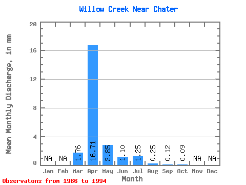
| Statistic | Jan | Feb | Mar | Apr | May | Jun | Jul | Aug | Sep | Oct | Nov | Dec | Annual |
|---|---|---|---|---|---|---|---|---|---|---|---|---|---|
| Mean | 1.76 | 16.71 | 2.84 | 1.09 | 1.25 | 0.25 | 0.12 | 0.09 | |||||
| Standard Deviation | 3.08 | 19.49 | 4.04 | 2.38 | 3.16 | 0.44 | 0.25 | 0.15 | |||||
| Min | 0.00 | 0.00 | 0.00 | 0.00 | 0.00 | 0.00 | 0.00 | 0.00 | |||||
| Max | 12.82 | 60.11 | 14.49 | 12.70 | 14.05 | 1.76 | 0.94 | 0.52 | |||||
| Coefficient of Variation | 1.75 | 1.17 | 1.42 | 2.18 | 2.53 | 1.75 | 2.20 | 1.73 |
 Return to R-Arctic Net Home Page