|
|
|||||||||||||||||
| Point ID: 2908 | Downloads | Plots | Site Data | Other Close Sites | Code: 05MH001 |
|
|
|||||||||||||||||
| Download | |
|---|---|
| Site Descriptor Information | Site Time Series Data |
| Link to all available data | |
| View: | Time Series | All |
| Units: | m3/s |
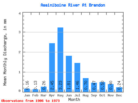
| Statistic | Jan | Feb | Mar | Apr | May | Jun | Jul | Aug | Sep | Oct | Nov | Dec | Annual |
|---|---|---|---|---|---|---|---|---|---|---|---|---|---|
| Mean | 0.16 | 0.13 | 0.26 | 2.45 | 3.23 | 1.81 | 1.46 | 0.70 | 0.47 | 0.50 | 0.40 | 0.24 | 11.38 |
| Standard Deviation | 0.14 | 0.11 | 0.20 | 1.46 | 3.30 | 1.67 | 1.52 | 0.74 | 0.52 | 0.56 | 0.36 | 0.21 | 8.61 |
| Min | 0.03 | 0.02 | 0.03 | 0.24 | 0.29 | 0.12 | 0.06 | 0.03 | 0.04 | 0.06 | 0.06 | 0.03 | 1.36 |
| Max | 0.66 | 0.60 | 1.12 | 7.11 | 13.45 | 7.90 | 8.16 | 3.18 | 2.74 | 3.15 | 1.70 | 0.97 | 36.23 |
| Coefficient of Variation | 0.85 | 0.85 | 0.80 | 0.60 | 1.02 | 0.92 | 1.04 | 1.07 | 1.11 | 1.11 | 0.91 | 0.88 | 0.76 |
| Other Close Sites | ||||||
|---|---|---|---|---|---|---|
| PointID | Latitude | Longitude | Drainage Area | Source | Name | |
| 2916 | "ASSINIBOINE RIVER NEAR BRANDON" | 49.87 | 766661 | Hydat | ||
 Return to R-Arctic Net Home Page