|
|
|||||||||||||||||
| Point ID: 2903 | Downloads | Plots | Site Data | Code: 05MG008 |
|
|
|||||||||||||||||
| Download | |
|---|---|
| Site Descriptor Information | Site Time Series Data |
| Link to all available data | |
| View: | Time Series | All |
| Units: | m3/s |
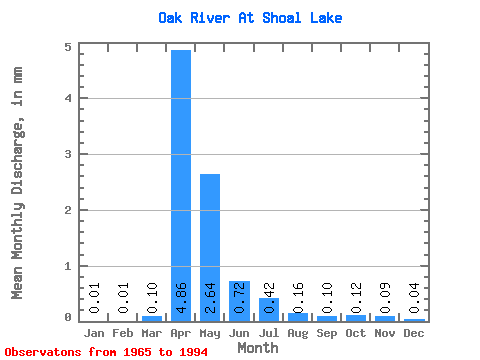
| Statistic | Jan | Feb | Mar | Apr | May | Jun | Jul | Aug | Sep | Oct | Nov | Dec | Annual |
|---|---|---|---|---|---|---|---|---|---|---|---|---|---|
| Mean | 0.01 | 0.00 | 0.10 | 4.87 | 2.63 | 0.72 | 0.42 | 0.16 | 0.10 | 0.12 | 0.09 | 0.03 | 10.56 |
| Standard Deviation | 0.05 | 0.02 | 0.23 | 6.39 | 3.55 | 1.04 | 0.63 | 0.30 | 0.38 | 0.47 | 0.37 | 0.14 | 12.40 |
| Min | 0.00 | 0.00 | 0.00 | 0.00 | 0.00 | 0.00 | 0.00 | 0.00 | 0.00 | 0.00 | 0.00 | 0.00 | 0.09 |
| Max | 0.23 | 0.07 | 0.96 | 27.66 | 12.53 | 4.01 | 2.08 | 1.08 | 2.04 | 2.51 | 1.57 | 0.60 | 44.28 |
| Coefficient of Variation | 4.36 | 4.36 | 2.18 | 1.31 | 1.35 | 1.44 | 1.50 | 1.87 | 3.86 | 3.91 | 3.93 | 4.14 | 1.18 |
 Return to R-Arctic Net Home Page